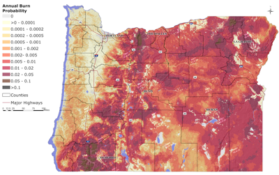
This is not a final map. This is a draft map of Oregon burn probability, which represents the average annual likelihood that wildfire will impact a specific location. It is not a forecast. Burn probability is just one component of wildfire hazard. The other is wildfire intensity.
Editorials reflect the views of The ≈ðÐΩ÷±≤•'s editorial board:
Publisher Heidi Wright; Editor Jody Lawrence-Turner; Editor Tim
Trainor and Editorial Page Editor Richard Coe. They are written by
Richard Coe.¬ÝContact: rcoe@bendbulletin.com
This is not a final map. This is a draft map of Oregon burn probability, which represents the average annual likelihood that wildfire will impact a specific location. It is not a forecast. Burn probability is just one component of wildfire hazard. The other is wildfire intensity.
On Andy McEvoy’s hard drive is the draft data that will shape Oregon’s new state wildfire map. McEvoy of Oregon State University, is part of that will mean changes for Oregonians.
The map will help Oregonians understand the hazard of wildfire near where they live.
It will help the government prioritize what it does in fire prevention and preparedness.
And what may matter the most to some people is that it will help identify places where state codes require the creation of defensible space. Those would be in areas that are defined as high hazard and defined as in the “wildland-urban interface.”
Insurance companies are
“There are a lot of people trying to protect us from fire,” Deschutes County Commissioner Phil Chang to develop the maps. “There are a lot of people who are trying to protect us from unnecessary regulation. There are a lot of people who are in the background really concerned about insurance premiums in the long run. I just want to re-emphasize for folks that these maps done well, done right will help us improve the fire safety of our homes and should help us reach a new place with the insurance industry where they are recognizing that meaningful work is being done in the state of Oregon to protect homes from fire.”
The plan is to officially release a draft map in mid-July at the same time as it is opened up to public comment.
So why bother to bring all this up now? Because when a previous version of the map was released it impelled much botheration for Oregonians.
It coincided with rising insurance rates for some property owners or difficulty even in getting insurance. It was the state of Oregon defining some properties where people live as essentially dangerous places to live. And it led to so much uproar in 2022 that the Oregon Department of Forestry withdrew the map.
The new map will be a bit different than the old. It is more circumspect. It goes from talking about risk areas to hazard areas. Those aren’t worlds apart, but there is a distinction. Hazard speaks to an acknowledgment of the likelihood of wildfire and what that intensity might be. To better understand risk, there also would have to be a more comprehensive understanding of the structures on a property. The state would have to do more work to be able to track when someone switched their siding to something more fire resistant or installed a metal roof.
The new map is still going to take some people by surprise. People who own property defined as high hazard and within the wildland-urban interface will be sent notices.
There is much more information about the new wildfire map here: .
Editorials reflect the views of The ≈ðÐΩ÷±≤•’s editorial board: Publisher Heidi Wright; Editor Jody Lawrence-Turner; Editor Tim Trainor and Editorial Page Editor Richard Coe. They are written by Richard Coe. Contact: rcoe@bendbulletin.com
Editorials reflect the views of The ≈ðÐΩ÷±≤•'s editorial board:
Publisher Heidi Wright; Editor Jody Lawrence-Turner; Editor Tim
Trainor and Editorial Page Editor Richard Coe. They are written by
Richard Coe.¬ÝContact: rcoe@bendbulletin.com
Keep it Clean. Please avoid obscene, vulgar, lewd,
racist or sexually-oriented language. PLEASE TURN OFF YOUR CAPS LOCK. Don't Threaten. Threats of harming another
person will not be tolerated. Be Truthful. Don't knowingly lie about anyone
or anything. Be Nice. No racism, sexism or any sort of -ism
that is degrading to another person. Be Proactive. Use the 'Report' link on
each comment to let us know of abusive posts. Share with Us. We'd love to hear eyewitness
accounts, the history behind an article.


(0) comments
Welcome to the discussion.
Log In
Keep it Clean. Please avoid obscene, vulgar, lewd, racist or sexually-oriented language.
PLEASE TURN OFF YOUR CAPS LOCK.
Don't Threaten. Threats of harming another person will not be tolerated.
Be Truthful. Don't knowingly lie about anyone or anything.
Be Nice. No racism, sexism or any sort of -ism that is degrading to another person.
Be Proactive. Use the 'Report' link on each comment to let us know of abusive posts.
Share with Us. We'd love to hear eyewitness accounts, the history behind an article.